TALL TALES of CLAMS AND CURRENTS… BUT TRUE
We thought this brief article from the May 24, 1889 Mason County Journal worth sharing…
—————-
When General Winfield Scott was on the Sound to quiet the San Juan disturbance in 1859 [the Pig War], Lieutenant R. N. Scott was detailed from Fort Townsend to act as an aid on the general’s staff, of which a Col. Thomas was a member.
Lieutenant Scott was noted for his bright, happy nature, and he afforded his military associates much amusement by his manner of relating yarns concerning Puget Sound, a fund of which he had acquired during his stay at Fort Townsend.
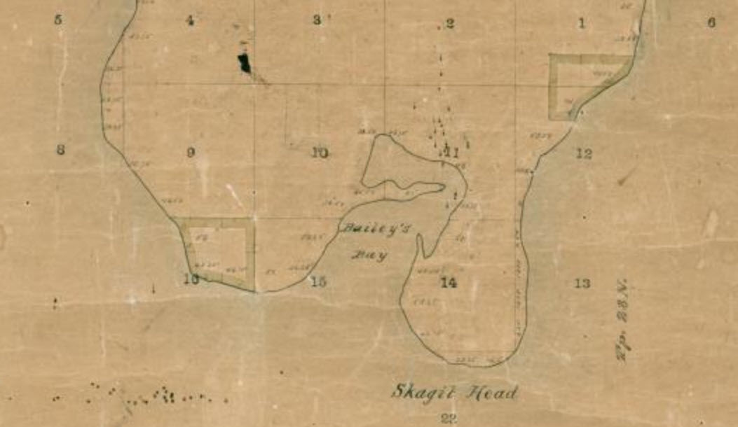
Among the tales he related to Col. Thomas, according to James G. Swan, Esq., was that of crows stealing clams from the hogs… the current always running one way at Skagit Head… the trees growing so tall that a man had to look up three times before he could see the top.
These stories seemed so improbable to Col. Thomas that he reported the young lieutenant to General Scott as making sport of his superior officer.
The general sent for the lieutenant and when he appeared, said:
“”Mr. Scott, I am informed that you say the hogs of Puget Sound root out clams with their snouts, and the crows steal the clams away from the hogs, and, flying up in the air, drop the clams from their beaks and they are broke by the fall, when the crows eat them. Is that so, Mr. Scott?”
“Yes, General.”
“Mr. Scott, I am informed that you say there is an enormous hollow cedar tree on the Chehalis River into which one hundred tons of hay have been stowed. Is that so, Mr. Scott?
“Yes, General.”
“Mr. Scott, I am informed that you say that trees grow so tall in this country that a person has to look three times before he can see the top. Is that so, Mr. Scott?”
“Yes, General.”
“Mr. Scott, you may report yourself to Major Haller for duty. Your services are not required here.”
——————-
We were curious about the comment about the Skagit Head current, which warranted a little further search.
We found this well-written explanation in the online blog post “Riding the Rip” by Greg Van Belle, in the April 10, 2019 issue of Northwest Yachting.
An excerpt is provided below, but for the full article (which is excellent), click the link below.
“The Salish Sea is a maze of channels, islands, deltas, and reefs. There is no single forecast that covers it, and there is no quick way to learn the nuances of its currents. If you drained the water from the Puget Sound, you would see huge
canyons and constricted passes. Rock formations lurk just below the surface. Sandbars stretch out far into bays….
Lower Puget Sound has 1,300 miles of complicated shoreline, pinching and redirecting an average of 1.3 cubic miles of salt water on each tidal exchange, most of it running through Admiralty Inlet…
Imagine a flow of water heading north from somewhere between Seattle and Bainbridge Island. Notice the constrictions and side channels. Absent of other forces, that water is going to hit Whidbey Island and split off in two directions.
One flow would head northwest toward Port Townsend, the other northeast toward Everett. Except there is a concurrent flow coming south out of Port Gardner, which joins the water coming from the south, creating a tide rip somewhere near the fertile salmon fishing grounds of Possession Point.
Travel around the chart and trace where you think the water should flow with different currents. You quickly see the problem areas. It isn’t as simple as draining or filling a bathtub twice a day….”
—————
One wonders whether Lieutenant Scott kept telling ‘tall tales’ of Puget Sound. We hope so.